The Smoky Mountains are full of expansive outlooks and deep valleys, and they’re absolutely alluring to motor through at any time of year. Whenever you visit, make sure to get out of town and explore the area’s beautiful surroundings. Here are the best scenic drives in the Great Smoky Mountains so you can do so from the comfort of a car (or RV).
Roaring Fork Motor Nature Trail

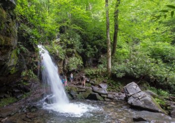
Location: Rainbow Falls, Gatlinburg
Total Distance: 5.5 miles
The Roaring Fork Motor Nature Trail is an official National Park Service (NPS) scenic drive along a 5.5-mile loop road. Although the road can be safely driven in a few minutes, the loop invites you to go slow and explore along the way.
Even the least outdoorsy are rewarded along this drive, as plenty of grist mills and old cabins are visible from the road. Pull over to admire the most striking ones, and don’t be afraid to get out of the car for that ideal photograph (remember these may be private buildings).
To see this particular area in greater detail, stop at Noah “Bud” Ogle, Rainbow Falls or Grotto Falls for some exploration. The falls trails are somewhat more challenging, while Noah “Bud Ogle offers a pleasant walk around a historic farmstand.
Insider Tip: Roaring Fork Motor Nature Trail is closed during winter.
Cades Cove Loop Road

Location: Cove Loop Road, Cades Cove
Total Distance: 11 miles
Cades Cove Loop Road is another National Park Service-recognized loop road that weaves through a deep valley. The loop guarantees sightings of three churches, a working grist mill, log houses, and barns, and it often affords plenty of wildlife sightings. Deer, black bears, coyotes, raccoons, groundhogs, turkeys, and skunks are all regularly spotted. Drive slow so you don’t hit them, and stay near the car whenever you get out for photographs — these are all wild animals.
Before embarking on the loop road, stop to pick up one of the inexpensive guidebooks. You’ll learn more about the history of the valley and what’s along the road. Just be sure to read before you drive, since you’ll want to be watching the forest as you go.
Insider Tip: Because wildlife sightings are so common, traffic can get congested during peak seasons. Consider biking or walking the road on Wednesdays, when it’s closed to vehicles.
Rich Mountain Road
Location: Cove Loop Road, Cades Cove
Total Distance: 7 miles
For the more rugged vehicles, Rich Mountain Road is a one-way branch off of Cades Cove Loop Road. The 7-mile road has steep grades, switchbacks, and unpaved gravel in sections, so it’s only recommended for four-wheel vehicles. For the more capable trucks and SUVs, though, this offers access to a less touched section of Cades Cove.
Expect to see fewer buildings along this section, but possibly more wildlife depending on the time of day. Early morning and evening are generally animals’ most active times of day, although you might want to venture up this way even during mid-day if the loop road is too overcrowded.
Remember when taking this road that it’s a one-way adventure. Complete the entire Cave Codes Loop Road and circle back to where Rich Mountain Road breaks off if you want to see each in its entirety. That way, you can venture off to the next attraction after reaching the mountain road’s peak.
Insider Tip: Remember this road will be inaccessible on Wednesdays when the Cades Cove access is closed to vehicle traffic.
Upper Tremont Road
Location: Lynn Camp Prong, Tremont
Total Distance: 8 miles (4 miles one-way)
Upper Tremont Road is majestic during fall when leaves are changing, but it’s also a pleasant drive any time of year if you want to get away from the crowds. The dead-end road is much less traveled than many of these other scenic drives — even though it’s also on the way to Cades Cove Loop Road and Rich Mountain Road for many.
Visitors who want to explore the area on foot will be most rewarded by this drive. Pull-over parking lots are located at several trailheads that lead to waterfalls and rivers. The sights for drivers who prefer to remain in their car are less enticing, except for during autumn. If hiking, make sure to pick up a self-guided tour booklet so you can identify the best trails.
Insider Tip: Although significant portions of Upper Tremont Road are unpaved, this road isn’t steep like Rich Mountain Road. Most vehicles can handle this road without issue.
The Tail of the Dragon
Location: U.S. Route 129, Tail of the Dragon
Total Distance: 22 miles (11 miles one-way)
The Tail of the Dragon isn’t where you want to take a large RV. Aptly named, the road’s 11 miles contain 300 curves that whip sports cars and motorcycles around tight turns. For adrenaline seekers, this is the scenic drive that offers views alongside thrills.
Most people only slow down for the curves and not the scenery here. There is one outlook that’s worth pulling over for, though. The view looks out over the Smokies on clear days.
Insider Tip: The Tail of the Dragon crosses between Tennessee and North Carolina. It’s probably the most fun way to travel between the two states.
Little River Road

Location: Gatlinburg to Townsend
Total Distance: 36 miles (18 miles one-way)
Little River Road follows train tracks that originally took passengers between Gatlinburg and Townsend, and it remains the most picturesque way to travel between these towns. Admire the woods, wildflowers, rivers, and waterfalls that permeate this landscape as you go to your next attraction. The road is 18 miles long, but you’ll probably want to take the same route back because it’s so beautiful.
Insider Tip: Watch for black stains along the rocks, which remain from when trains came through here.
Newfound Gap Road

Location: Gatlinburg to Cherokee
Total Distance: 63 miles (32 miles one-way)
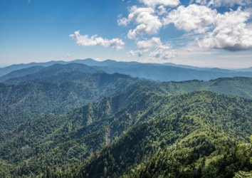
Newfound Gap Road is the primary way to travel between Gatlinburg and Cherokee, and it’s also one of the nicest routes. Trading The Tail of the Dragon’s thrills for more relaxed driving, the road allows you to look over a large portion of the Smoky Mountains. Be sure to stop at the Newfound Gap itself for some pictures of the deep gorge.
Insider Tip: Time your trip from Cherokee to Gatlinburg for dusk if possible — the sunsets are mesmerizing.
Clingmans Dome Road

Location: Newfound Gap, Tennessee-North Carolina Border
Total Distance; 14 miles
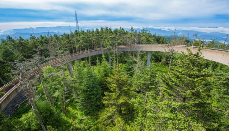
Clingmans Dome Road takes you to the highest elevation in the Smoky Mountains. The dead-end offshoot is 7 miles one way and departs Newfound Gap Road near the gap itself.
The drive itself provides views of the Smoky Mountains on both sides. Make sure to get out at the end, however, and take the half-mile hike to an observation tower. This is the highest elevation in the Smokies and anywhere on the Appalachian Trail.
Insider Tip: Bring a light jacket or sweatshirt for the hike. Temperatures up this high can be approximately 10 degrees cooler than in the valleys.
Enjoy the Smoky Mountains’ Scenic Drives
The Smoky Mountains’ towns are full of attractions, dining, shops, and other things to do. Spend some time simply driving through the mountains, though. These scenic routes will show you what attracted people here in the first place.